The People’s Republic of China, also known simply as China, is located in East Asia. China is the largest country in Asia (not counting Russia, which spans two continents). The People’s Republic of China (PRC) covers over 9.5 million square kilometers.
Regarding land area, China is the third-largest country in the world. It is also the largest country in the world in terms of population. As of the country’s 2020 census, China had a total population of over 1.4 billion people.
China is also an incredibly ancient and influential society. Its languages, political structures, culture, and worldwide influences can be traced back thousands of years.
In more recent times, the country has undergone massive demographic, cultural, and economic shifts. Today, the modern China political map reflects many of these shifts.
Political Map of China

Where is China?
The People’s Republic of China is located on the eastern-central end of the Asian continent. Because of its immense size, China is easy to spot on a map.
For comparison, China is slightly larger than the United States and is more than three times the size of India, the next-largest country in Asia (Russia is considered both a European and Asian country, making comparisons somewhat difficult).
China borders the Pacific Ocean on its eastern shoreline. On land, China borders Russia, India, Mongolia, Vietnam, North Korea, and others. China also shares a maritime border with Japan, as well as other disputed maritime territories, primarily in the South China Sea.
Neighboring Countries
On land, China shares a border with 14 other countries:
Countries on China’s northern border:
- Kazakhstan
- Mongolia
- Russia
Countries on China’s western border:
- Kyrgyzstan
- Tajikistan
- Afghanistan
- Pakistan.
Countries on China’s southern border:
- India
- Nepal
- Bhutan
- Myanmar (Burma)
- Laos
- Vietnam
Countries on China’s eastern border:
- North Korea
- Russia
Because of its geographic orientation, China meets with the Russian border twice, both to the north and the east. Interestingly, China ties with Russia for the country with the highest number of neighboring countries. Both nations border 14 other countries.
Surrounding Seas
China’s east coast borders four seas and one bay of the Pacific Ocean.
- Yellow Sea: The Yellow Sea is located along the northern part of China’s coastline. The Yellow Sea separates China from South Korea.
- East China Sea: The East China Sea is in the center of China’s coastline. It is between China and Japan.
- South China Sea: The South China Sea is off of China’s southernmost coast. The South China Sea separates China from the Philippines, Taiwan, Malaysia, Indonesia, and most of Vietnam. China’s southern coast is an important shipping and trading center. It is estimated that $5.3 trillion of trading goods passes through the South China Sea every year.
- Bohai Sea: The Bohai Sea, along with Korea Bay, is the northernmost reaches of the Yellow Sea. The Bohai Sea is nestled into the northern part of mainland China and is the sea closest to Beijing, the capital city of China.
- Korea Bay: Korea Bay is the body of water between the Bohai Sea and the Yellow Sea. It borders Northeast China and North Korea.
China: Map of Regions and Provinces
China Provinces Map
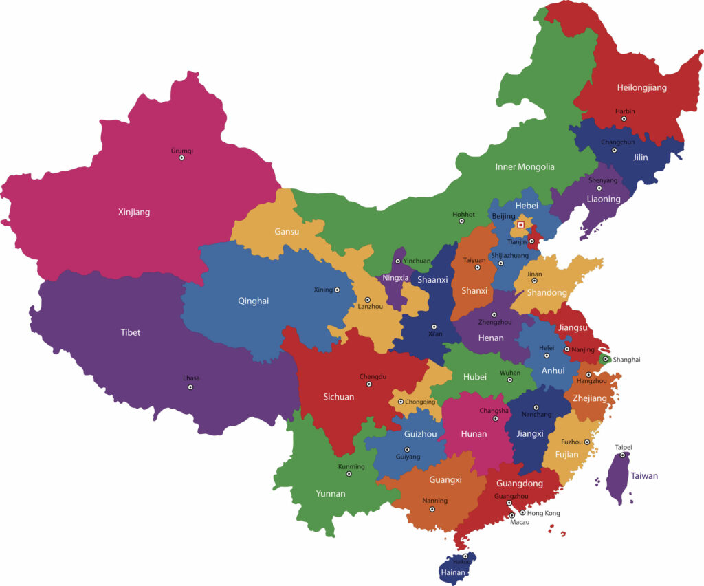
On a typical map of China, the country is divided into six major geographical regions. Within each of these six geographic regions, the country is further divided into provinces, municipalities, and autonomous territories.
China Regions Map
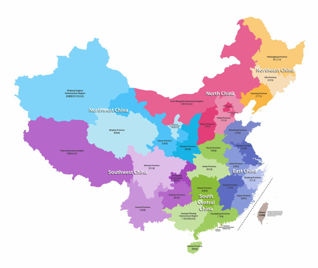
Region 1: North China
Provinces/Regions
- Beijing
- Tianjin
- Hebei
- Shanxi
- Inner Mongolia
North China is situated between the regions of Northeast China and Western China. The region’s largest city is Beijing, the national capital of the People’s Republic of China (PRC). The Beijing Municipality has a population of approximately 22.5 million people.
Other large cities in the North China region include Tianjin, Taiyuan, and Shijiazhuang. These cities are each the seat of their respective province, although Tianjin, like Beijing, is technically a municipality and not a province.
Inner Mongolia is the region’s only autonomous region. Autonomous regions are the highest level of the PRC’s administrative divisions, and it allows a region or province more control over economic and legal matters. Inner Mongolia is also home to one of China’s largest ethnic minority groups, the Mongols.
Winters tend to be long and harsh in the North China region, and the overall climate is dry. Much of the topography is the great plains and steppes typical of Central Asia. Wheat and millet are important crops in the region. A lot of livestock are raised in North China, and it is home to several different mining industries.
The capital city, Beijing, is the region’s most prominent feature. Beijing, formerly known as Peking, is an ancient city, over 3,000 years old. It is home to seven UNESCO world heritage sites, including the Great Wall and the Forbidden City. As China’s capital and its second-largest city, Beijing has become an epicenter of Chinese culture.
North China is considered the Cradle of Chinese Civilization; the famous Peking Man was found outside Beijing in 1929.
Modern Beijing has joined with other capital cities in Northern China to form the Beijing-Tianjin-Shijiazhuang Hi-Tech Industrial Belt, a hub for the tech industry and intellectual training. Many forms of public transportation have been built in this area to help facilitate technological development and growth.
Region 2: Northeast China
Provinces
- Liaoning
- Jilin
- Heilongjiang
Unlike North China, neighboring Northeast China is predominantly Han Chinese. The area accounts for about 8% of China’s total population and was also formerly known as Manchuria.
The main geographic feature of the Northeastern region is the North China Plain, which is an important agricultural center for the region and China as a whole. The Yellow River runs through the North China Plain and empties into the Bohai Sea, creating a fertile river delta throughout the area.
The North China Plain is very densely populated and is an important piece of China’s agricultural supply chain. Crops such as wheat, corn, sorghum, cotton, and ground produce are all grown on the North China Plain. The area is nicknamed “Land of the Yellow Earth.”
The region is also historically associated with the industry. In the early 20th century, Northeast China was one of the first areas to industrialize. In more recent times, however, as industrialization has given way to the tech revolution, the area has struggled and become known as a “rust belt” region.
Because of its early industrialization, this area is heavily urbanized. The region’s largest city is Shenyang in the Liaoning province, with a population of over eight million.
Liaoning is the region’s smallest but most densely populated province, with a total population of almost 44 million people. Heilongjiang is the next largest, with 38 million, followed by Jilin, with 27.5 million.
Heilongjiang was formerly a Japanese protectorate known as Manchuria, a name that sometimes gets applied to the whole region. The Japanese invaded and conquered the area in the 1930s, but Chinese sovereignty of the region was restored after World War II.
Region 3: East China
Provinces/Municipalities
- Anhui
- Fujian
- Jiangsu
- Shandong
- Zhejiang
- Shanghai (Municipality)
- Jiangxi
- Taiwan (disputed)
The East China region is very important to the PRC. China’s coast has been a significant source of wealth and influence for centuries, trading and exporting goods to the rest of the world.
Shanghai is the largest city in both the East China region and the entire country. As of 2019, Shanghai’s population was over 26 million people.
Taiwan and other small islands off the coast of East China are disputed territories. The People’s Republic of China claims Taiwan as part of mainland China and under their governing authority.
On the other hand, Taiwan and surrounding islands, also known as the Republic of China (ROC), claim to be self-governing. The split happened after the Chinese Civil War and has never been fully resolved.
The region’s most important city is Shanghai. Also the largest city in the world, Shanghai is the only city in East Asia to have an annual Gross Domestic Product (GDP) greater than its national capital. Shanghai was originally a nondescript fishing village on China’s east coast, but in the 1930s it began to grow into the important urban center it is today.
Today, Shanghai is an important center for finance and trade, partly due to its favorable port. The city is often a showcase of the success of the Chinese economy. Shanghai has long had more Western influence than other parts of China because of its location and function as a trading port.
Other regional highlights include the Yangtze River, which flows into the East China Sea at the ports of Shanghai. Much of the topography of the East China region is wetlands, rivers, and mountains. The summers are hot and humid, and the winters tend to be mild.
Because of this overall warmer climate, the East China region can produce many crops throughout the year. Tropical fruits, rice, and fishing are all major exports of this region.
Region 4: South Central China
Provinces/Autonomous Region
- Guangdong
- Hainan
- Henan
- Hubei
- Hunan
- Guangxi (Autonomous Region)
South Central China is the least uniform and most diverse area of all the regions of China. Because of these many differences, the South Central region is often further divided into Central China and South China, although this is not an official government designation.
The “South China” designation often includes the Guangdong province, the Guangxi Zhuang Autonomous Region, and the Hainan province. Hong Kong and Macau are often included in these areas due to their location.
The South China region is densely populated and composed of many different ethnic groups. The primary language of the area is Cantonese, not Mandarin Chinese.
The Guangxi Zhuang Autonomous Region contains the highest concentration of ethnic minority groups within China. The Zhuang people are the area’s most prominent ethnic minority group, making up 32% of the population.
The islands of Hong Kong and Macau are often also included as part of South Central China, but their exact status and place within the Chinese government are disputed. For now, Hong Kong and Macau are recognized as Special Administrative Regions of the PRC.
“Central China” includes the remaining Henan, Hubei, and Hunan provinces. The area’s largest city is Wuhan, with a population of 11.1 million. Wuhan, located in the Hubei province, is now famous as the site of origin for the COVID-19 virus. The Hunan province is known as the birthplace of Mao Zedong and for its beautiful rural landscapes.
Henan province is considered the birthplace of Chinese civilization. Until about 1,000 years ago, Henan was the center of Chinese culture, economic power, and political center. It has many historical and heritage sites around the province. Four out of the Eight Great Ancient Capitals of China are located in Henan.
Region 5: Southwest China
Provinces/Municipality/Autonomous Region
- Sichuan
- Chongqing
- Yunnan
- Guizhou
- Tibet (Autonomous Region)
The Tibet Autonomous Region has not been traditionally included in the Southwest China region, but the current official government definition includes it.
Southwest China is considered a more rural area than many of the eastern provinces. The region’s total population is roughly 195 million, and there are only four cities in Southwest China with a population of over one million.
Southwest China is a relatively mountainous region. Other geographic features include the Sichuan Basin (located in Sichuan province) and the Yungui Plateau, located in the Yunnan and Guizhou provinces.
The Sichuan Basin is a very fertile and agriculturally important area in the Southwest China region. The basin has a mild climate, so the area can produce crops for much of the year. It is a major producer of tea, herbs, grain, and silk. Livestock is also raised in the area, such as sheep and pigs.
Southwest China is a very diverse region and is very different from the rest of China in many ways. The people of Southwest China are very ethnically diverse, with Han Chinese making up only about 63% of the region’s population.