New streamlined approach to detect and monitor wildfires
Wildfires in the Western U.S. in 2021 burned millions of acres of land, damaging homes and businesses and decreasing air quality across the region. According to the National Oceanic and Atmospheric Administration’s National Centers for Environmental Information, these wildfires were responsible for more than $11 billion in damages.
“Fires are becoming more of a national concern with climate change and drought in the Western U.S. that is unprecedented in the last 1800 years,” says Brad Pierce, director of the University of Wisconsin–Madison Space Science and Engineering Center.
To combat this growing problem, NOAA has awarded nearly $3 million to SSEC for research led by Pierce that will streamline the nation’s satellite-based fire detection and monitoring systems. These improvements will lead to more timely information for forecasters tasked with alerting the public about fires and fire managers responsible for extinguishing them.
Current satellite fire detection approaches are fragmented, with separate systems for separate satellites. There is no national system to seamlessly merge the information from these disparate systems to issue timely alerts and information about potential and growing fire threats.
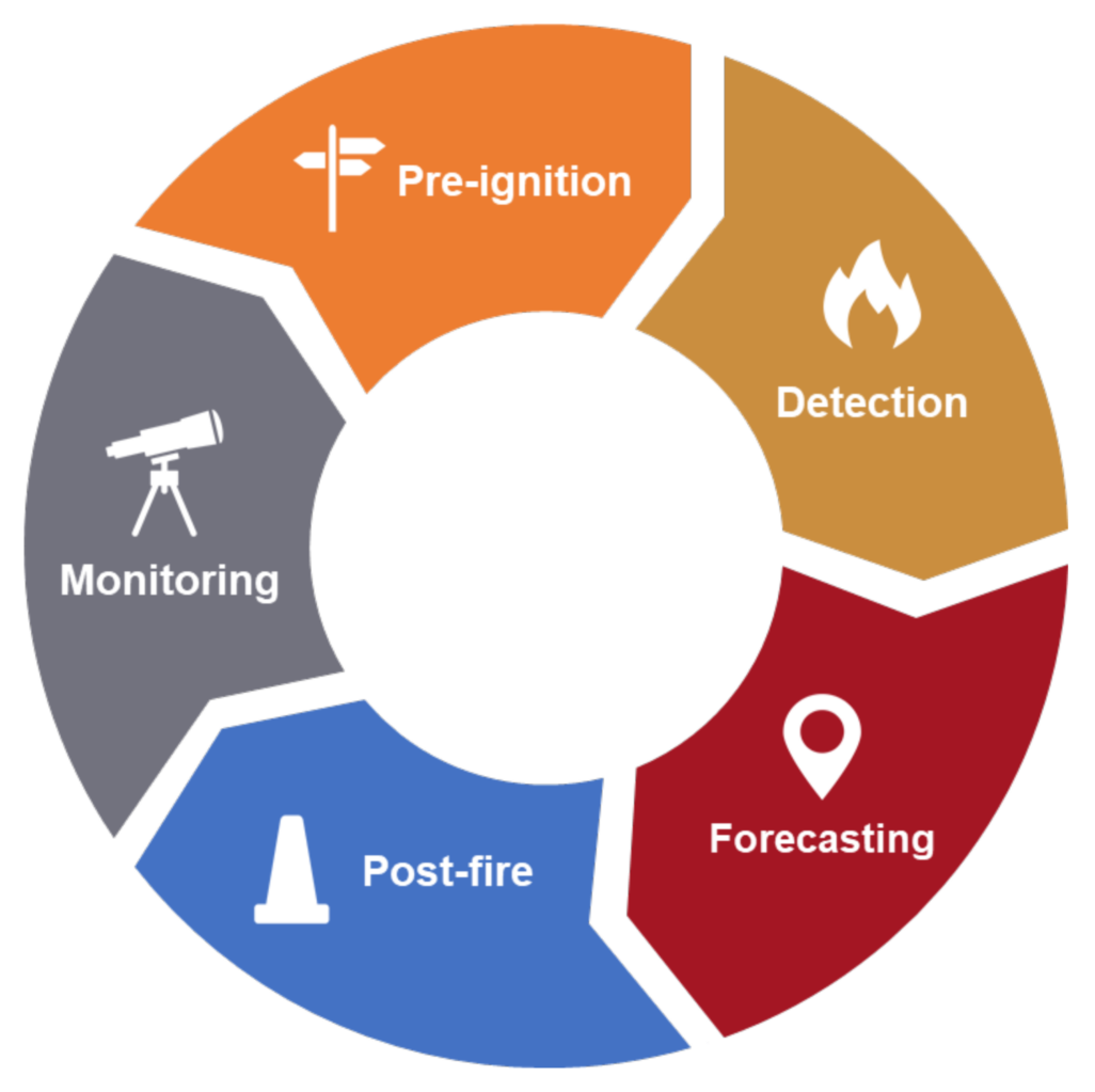
To address this gap, Pierce and his team will establish a proven satellite-based system that, regardless of sensor type, will deliver real-time warning and monitoring of wildfires across the U.S. By combining observations from different satellite platforms, the system will take advantage of the spatial resolution of polar sensors and the temporal resolution of geostationary sensors to more precisely determine where and when fires may be occurring. The team also plans to expand the system to include a nowcasting capability.
“One of the primary goals is the development of a really robust algorithm for automated detection of fires that can be applied to any weather satellite,” says Mike Pavolonis, who serves as the NOAA program manager for this research and is stationed at SSEC’s Cooperative Institute for Meteorological Satellite Studies.
Improving satellite-based fire detection is critical because satellite sensors may provide the first eyes on new fires, as humans and cameras cannot see everywhere. And with the amount of satellite data now available, machine learning techniques are needed to quickly identify potential fire ignition sources, such as lightning, and predict which fires might intensify. The sooner fires are found, the sooner fire managers can develop plans and allocate resources to manage and extinguish them.
The team has already developed a prototype fire detection system. The prototype is based on previous CIMSS work creating an operational volcanic cloud monitoring software system known as the VOLcanic Cloud Analysis Toolkit. VOLCAT detects volcanic eruptions, tracks the evolution of volcanic plumes and issues alerts to its users.
As Pierce explains, “Detecting fires is a very similar problem from a physics perspective.”
This initial VOLCAT Wildfire prototype will be refined, as the team continues to evaluate and upgrade the underlying algorithm, as well as adding more useful information to the dashboard.
CIMSS plans to transition the VOLCAT Wildfire system from the research environment to operations by use of a DevOps framework, “which means that there’s continuous interaction between the science developers and operational implementation,” as Pierce explains. In addition to bringing in experts in DevOps, SSEC has assembled a team of experts in data science, fire research, web development, software engineering and geographical information systems.
Over time they will develop a fire database, containing parameters such as fire detection, soil moisture, fuel moisture, terrain slope, local winds, humidity and temperature that will allow researchers to study fire behavior and create nowcasting models.
Both Pavolonis and Pierce emphasized the importance of partnerships to developing the new fire detection system, including with other cooperative institutes, university research centers and federal agencies such as the National Weather Service and the U.S. Forest Service. In addition, users will provide feedback to help shape it to their needs and priorities, while partners will continue to contribute from their areas of expertise to strengthen the system.
“This opportunity is an example of why cooperative institutes like CIMSS where federal researchers are working in partnership with academic researchers are a key to standing up something like this new capability in a short time,” says Pierce.
This work is supported by NOAA.
Cover image credit: Sippakorn Yamkasikorn